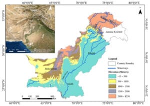
The Indus River, one of the longest and most historically significant rivers in the world, plays a crucial role in shaping the geography, culture, and economy of South Asia. It stretches approximately 3,180 kilometers from its source in the Tibetan Plateau near Lake Mansarovar, flowing through China, India, and Pakistan, before emptying into the Arabian Sea near Karachi. This river, often regarded as the lifeline of Pakistan, has been the cradle of the ancient Indus Valley Civilization and continues to be pivotal in the region’s agriculture, hydrology, and biodiversity.

Origin of the Indus River
The Indus River originates from the Tibetan Plateau, specifically near Lake Mansard in the Kailash Mountain Range in southwestern Tibet. From its source, the river flows northwest into Ladakh in India, before making a sharp turn southward into Pakistan. Along its course, the river is fed by numerous glaciers, including the Siachen Glacier and the Baltoro Glacier, which are part of the Karakoram Range. The high-altitude glaciers contribute to the river’s flow, especially during the summer months, when melting snow and ice increase water levels significantly.

Historical Significance
The Indus River is not just a geographical feature but also the cradle of one of the world’s oldest civilizations. The Indus Valley Civilization, which flourished around 2500 BCE, is considered one of the three early cradles of human civilization, alongside the Mesopotamian and Egyptian civilizations. This civilization, spread across what is now Pakistan and northwestern India, relied heavily on the Indus River for agriculture, transportation, and sustenance. Major cities like Harappa and Mohenjo-Daro developed along its banks, making the river a critical artery for trade and communication.
Importance of the Indus River for Agriculture
In modern times, the Indus River is vital for the agricultural economy of Pakistan and parts of northwestern India. The river is the primary source of irrigation water in the Indus Basin, which spans approximately 1.12 million square kilometers, making it one of the largest irrigation systems in the world. The Indus Waters Treaty of 1960, signed between India and Pakistan, ensures the equitable distribution of water resources from the river and its tributaries. Major crops such as wheat, rice, cotton, and sugarcane are cultivated in the region, sustained by the waters of the Indus.
Hydrological Importance
The Indus River is not just vital for irrigation but also plays a crucial role in the overall hydrology of the region. It helps in replenishing underground aquifers and supports the freshwater ecosystem. The river and its tributaries are home to diverse species of fish, birds, and other wildlife. Furthermore, the river’s flow regulates the temperature and weather patterns in the region, particularly in the arid and semi-arid areas of Punjab and Sindh provinces in Pakistan.
The Indus Delta and Biodiversity
As the Indus River approaches its mouth in the Arabian Sea, it forms the Indus Delta, a sprawling area rich in biodiversity. Covering about 600,000 hectares, the Indus Delta is one of the largest delta regions in the world and is crucial for marine life, including various species of fish, shrimp, and other aquatic organisms. The mangrove forests in the delta are vital for coastal protection and act as natural buffers against sea-level rise and storm surges. However, due to reduced water flow caused by damming and irrigation upstream, the delta region faces severe ecological stress, leading to the loss of mangroves and saltwater intrusion.
Indus River and Hydroelectric Power
The river’s flow is harnessed for the generation of hydroelectric power, which is a key energy source for Pakistan. Major dams such as the Tarbela Dam and the Mangla Dam are built on the Indus and its tributaries. These dams not only help in generating electricity but also in flood control and water storage for agricultural purposes. Tarbela Dam, located in Khyber Pakhtunkhwa, is one of the largest earth-filled dams in the world, playing a pivotal role in energy production for the country.
Challenges Facing the Indus River
Despite its significance, the Indus River faces multiple challenges that threaten its sustainability. Climate change, reduced water flow due to upstream damming, and increasing demand for water in agriculture are putting immense pressure on the river’s ecosystem. The melting of glaciers in the Himalayas and Karakoram Range due to global warming is affecting the seasonal flow of the river, with potential implications for both flood risk and water shortages in the future.
The Indus Waters Treaty, which governs the sharing of water resources between India and Pakistan, has been a point of contention. Both countries are facing increasing water stress due to growing populations, urbanization, and industrialization. Managing the shared water resources of the Indus Basin requires ongoing cooperation and adaptation to changing climatic conditions.
Conclusion
The Indus River is an indispensable resource for the people of South Asia, particularly Pakistan. Its historical, agricultural, and ecological significance cannot be overstated. From the ancient Indus Valley Civilization to the modern hydrological and agricultural systems, the river has been and continues to be a lifeline for millions. However, with increasing environmental pressures and geopolitical challenges, the sustainable management of the Indus River is more critical than ever. Collaborative efforts between nations, coupled with innovative water management techniques, are essential to ensure that the Indus River remains a thriving natural resource for future generations.
https://www.youtube.com/watch?v=eCRXmXYDqGQ


